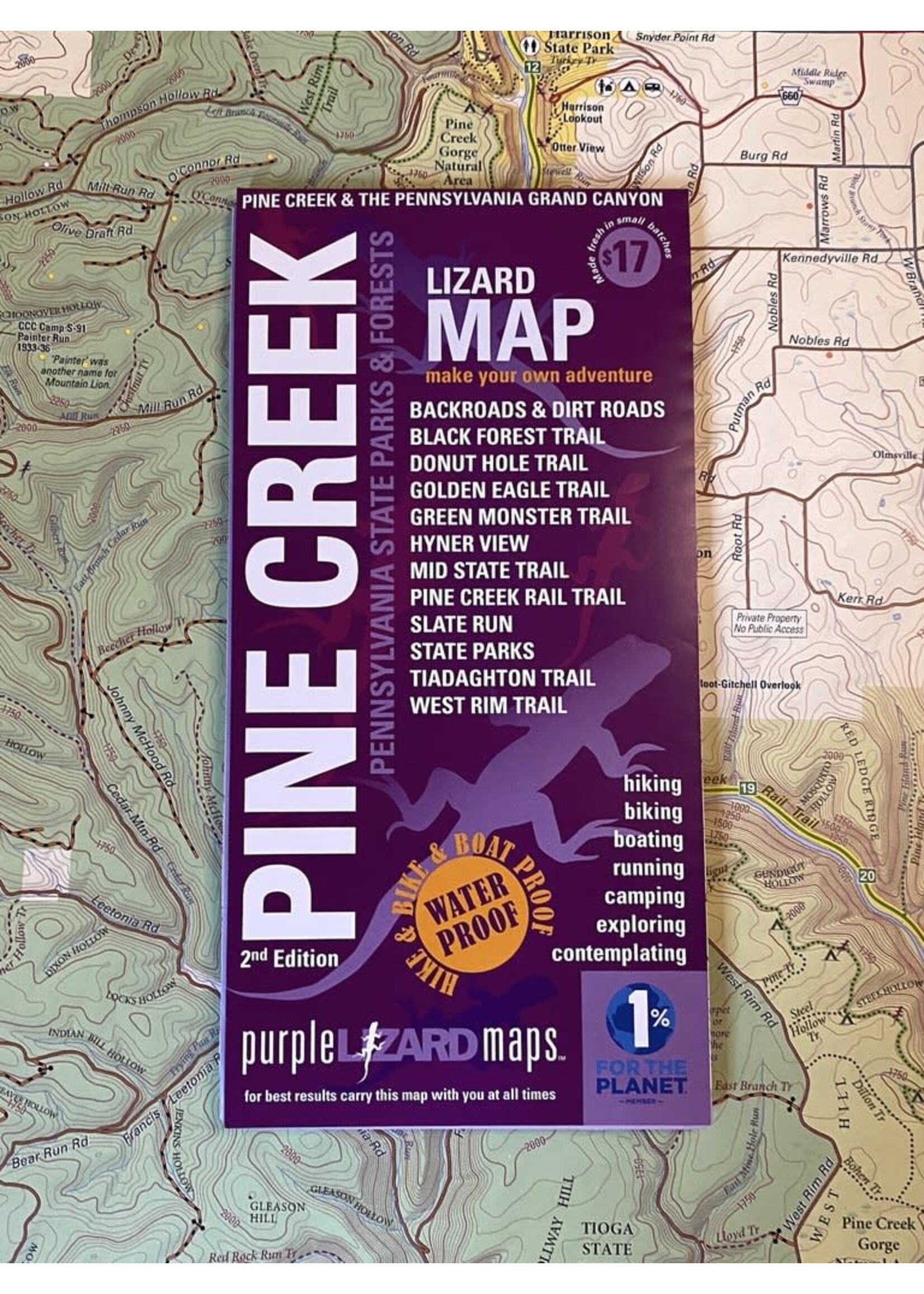
A beautifully designed, easy to read topographic map featuring contour lines, elevation data, shaded relief, and all the key details you need to plan your adventures: backroads and trails, trail use designations, road surfaces (paved/gravel/4wd), the Pine Creek Rail Trail, parking access, campsites, public lands, historic sites and more.
Lizard Maps are durable, waterproof, and give you the big picture – the map opens to 24” x 36” and folds easily to 4” x 8” to fit in your back pocket. The scale is 1:51,800 (1 inch = 0.8 mile). Includes both lat./lon. and UTM coordinate systems.
Public land: most of Tioga and Tiadaghton State Forests, sections of Susquehannock, Sproul and Bald Eagle State Forests, State Game Lands 68, 75, 89, 208, 268, 313; Leonard Harrison State Park, Colton Point State Park, Little Pine State Park, Hyner Run State Park and Zindel Park.
Destinations: Hyner View and the hang gliding launch and landing areas, historic CCC camps, Farrandsville iron furnace, and ‘The Stretch” catch and release fly fishing section of Pine Creek, one of America’s leading fly fishing destinations.
Roads: all Lizard Maps show which roads are paved, dirt/gravel or 4wd roads as well as which are gated. Perfect for bicyclists, dual sport riders and overlanders looking to put together a remote backcountry route across public lands.
Major hiking trails: the complete West Rim Trail, Tiadaghton Trail, 44-mile Black Forest Trail (considered to be one of the most difficult trails in PA), 50k Green Monster Trail. A section of the 90-mile Donut Hole Trail is shown from its southern end at Farrandsville to Hyner View State Park. Hikers can also find the Golden Eagle Trail, considered to be one of PA's best day hikes. A long section of the 323-mile Mid State Trail (MST) is mapped from Round Top Mountain in Bald Eagle State Forest at McElhattan, PA to Little Pine State Park and north to the Anna S Mine and Antrim, PA. Remote backpacking campsites are shown on the Black Forest, West Rim and Mid State Trails. The MST continues south on the Purple Lizard Bald Eagle Lizard Map.
"Thanks for adding confidence to my exploration, like helping show me to connect the Black Forest Trail to the West Rim Trail. Keep up the great work!" Tim in Maine
Major biking trails: the famous 62-mile Pine Creek Rail Trail from Wellsboro in the north to Jersey Shore in the south, with restrooms and mile markers for easy reference. The 50k Green Monster Loop is known for technical singletrack.
Even more trails! Lizard Maps highlight and designate public trails and paths including hiking, biking, equestrian, skiing, snowmobiling and rail trails managed by federal, state and local authorities, including Haneyville 18-mile ATV trail system, Lock Haven Riverwalk Trail and Bald Eagle Valley Rail Trail. The Susquehanna Water Trail is shown from mile 90 at Hyner Access to mile 59 at the confluence with Pine Creek.
Points of interest: campgrounds, picnic areas, river access, boat launches, water access campsites, primitive car camping sites, scenic overlooks, observation towers, waterfalls and lizard spots.
Wild and Natural areas plus: Wolf Run Wild Area, Algerine Wild Area, Asaph Wild Area, Reynolds Spring Natural Area, Pine Creek Gorge Natural Area, Bucktail Natural Area, Bark Cabin Natural Area, Mount Logan Natural Area, Black Ash Swamp Natural Area, Lebo Red Pine Natural Area, Miller Run Natural Area, Torbert Island Natural Area, Nessmuk Lake, and the West Branch Forest Preserve (Nature Conservancy).
Towns: Ansonia, Avis, Blackwell, Cedar Run, Jersey Shore, Lock Haven, Mill Hall, Slate Run, Waterville and Wellsboro, PA.